The Airborne Thermal and Land Applications Sensor (ATLAS) is a sensor, onboard a Learjet aircraft, from the NASA Stennis Space Center, Louisiana, that operates in the visual and infrared bands. ATLAS can sense 15 multispectral radiation channels across the thermal/near-infrared/visible spectrums. The data are radiometrically calibrated using onboard blackbodies for the thermal wavelengths and an integrating radiance sphere for the visible wavelenghts, corrected for atmospheric radiance, and georectified to map the coordinates system before data analysis. This ATLAS sensor was used in other field campaigns to investigate Urban Heat Islands (UHIs) in Atlanta, Salt Lake City, Baton Rouge, and Sacramento. 
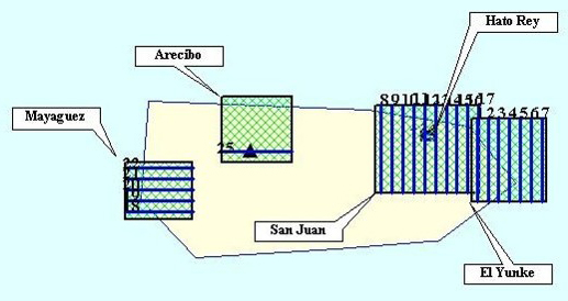
The San Juan, Puerto Rico, mission was conducted during 11–16 February 2004. The flight plan for the mission covered the San Juan metropolitan area; El Yunque National Forest, east of San Juan; Mayagüez, a city west of San Juan; and the Arecibo Observatory, on Puerto Rico’s central north coast; for a total of 25 flight lines. Each flight line covered an approximately 6.4 km swath width. The central area of San Juan was covered at five-meter resolution in day and night flights. The remaining areas were covered at 10-meter resolution. The completed imaging processing for the mission showed the presence of a constant UHI during the days of the mission in San Juan. Several additional upper air and ground instruments were used to support the ATLAS sensor data. Information from upper air soundings shows that during the days of the mission, the middle and high atmosphere in the Caribbean was relatively dry and highly stable. These conditions led to clear and dry skies which are necessary to use the ATLAS sensor. More information about the mission can be found in these related articles.
- GROUND STATION COVERING (PDF file)
- BAYAMON SENSOR (text file)
- CUPEY SENSOR (text file)
- CUSC SENSOR (text file)
- INTERAMERICANA SENSOR (text file)
- NWS SENSOR (text file)
- SAN PATRICIO SENSOR (text file)
- TOA BAJA SENSOR (text file)
- TRUJILLO ALTO SENSOR (text file)
- UPR BAYAMON SENSOR (text file)
- DORADO STATION (text file)
- POLYTECHNIC STATION (text file)
- RIO GRANDE STATION (text file)
- UPR RIO PIEDRAS STATION (text file)
Soil Moisture Experiments including Ground Penetrating Radar
Particulate Measurements


