

New York
Urbanized Weather Research and Forecasting
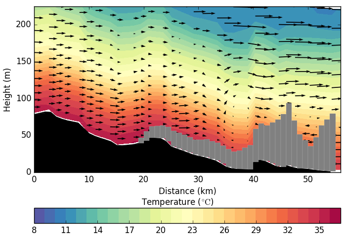
The Weather Research and Forecasting (WRF) model, coupled with a multi-layer urban canopy and building energy model, is used to evaluate impacts of urbanization on New York’s precipitation, temperatures, winds inside the urban boundary layer. The urban canopy model considers thermal effects like heat fluxes from roofs, streets, and walls, as well as the reflection and trapping of radiation in the street canyon, as well as the mechanical effects on the wind patterns from man-made structures. Meanwhile, the building energy model accounts for the sensible and latent heat exchanges through the building envelope due to the use or air conditioning, cooling towers, and water accumulated on impervious surfaces. High Resolution urban canopy parameters have been derived from the city’s Property Land Use Tax Lot Output (PLUTO), providing up to date urban morphology. Case studies have been performed for the 2010 and 2013 heat waves that affected the region, delving into the interaction of these extreme events and the urban surface and its impacts on temperatures and stability of the urban boundary layer. An operational forecast providing daily 72-hour weather has been online since 2013, showcasing the latest in our group’s urban weather prediction.
Understanding the Effects of Aerosols On Cloud Microphysics in Coastal Urban Environments

Urban environments influence precipitation formation via response to dynamic effects, while aerosols are intrinsically necessary for rainfall formation. In order to investigate the effects of aerosols on summer precipitation in the local environment of New York City (NYC), aerosol particle size distributions derived from the NASA Aerosol Robotic Network (AERONET) and high resolution land data from the National Land Cover Database (NLCD) were implemented into the Regional Atmospheric Modeling System (RAMS), and several cases were simulated for July 2007. Results suggest that LCLU provides the dominant forcing for urban precipitation; affecting precipitation rates, rainfall amounts, and spatial precipitation patterns. PSD then acts to modify cloud physics. Also, precipitation forecasting was significantly improved under observed PSD and current LCLU conditions.