

Collaborative Research: Integrated Socio-Technical Modeling Framework to Evaluate and Enhance Resiliency in Islanded Communities (ERIC)

5-km domain surface wind speed (m/s) simulated using WRF model during Hurricane Maria (September 20-September 21, 2017). The animation shows the storm track originating south east of the island and leaving at north west. For the 5-km domain maximum wind speed of 135 miles per hour was simulated by the model.
Recent extreme weather events in the eastern American coastlines and the Caribbean highlight the impact of the interdependencies of critical infrastructure systems when exposed to weather extremes, and how those interdependencies cause failures of physical assets leading to adverse impacts on the health and socio-economic wellbeing of the communities in those regions. A recent example is the extraordinary case of the island of Puerto Rico (PR), in the direct path of Hurricane Maria, and the near total failure of lifeline infrastructures. This event also exemplifies how extreme events compound endemic physical, social and economic vulnerabilities often present in remote or isolated communities. The associated cascading impacts, prior to and after Hurricane Maria, are clear evidence of our limited knowledge and readiness to anticipate risks in these complex engineered, physical and human systems. This reveals the urgent need to develop scientific and social frameworks and methodologies by which communities can assess their existing preparedness to extreme climatic events, and through a multi-stakeholder engagement process and engineering analysis, evaluate and implement alternative measures to enhance the resiliency of such communities. Using PR as the case study, we propose to develop a data driven modeling framework for understanding the complex physical and social vulnerabilities, and interdependencies that resulted in near total failure of the physical systems.
The research questions we aim to address include: a) How does socio-economic stability, governance and baseline conditions of the infrastructure impact the performance and resiliency of critical interdependent infrastructure systems in extreme weather conditions? b) What knowledge and methods are needed to guide strategies for enhancing system resiliency and restoration in islanded communities? c) How can we engage and inform experts and stakeholders about enhancing resiliency and effective failure mitigation strategies? We shall achieve these objectives by first implementing a data driven process of gathering human narratives as social data and a source of information to recreate the timeline and experience of Hurricane Maria, before, during and after the event. We seek to develop an integrated modeling and simulation framework, based on multi-layer distribution network theory. This framework will include the structural-based assessment results in the modeling of infrastructure behavior during and after a disaster. The focus of our study will be on the interdependencies of the electrical power, water distribution and communications systems. Our objective is to recreate the event using combination of system network models, geophysical data, and community data, to capture the sequence of the cascading failures and the corresponding societal impact as the event unfolded and during post-event recovery efforts. We seek to arrive at a level of understanding of this system of systems that will lead to informed solutions and recommendations that will minimize adverse impact, disruption, loss of life and suffering, in the face of future extreme events. We aim to address these emerging and novel challenges, provide the foundation for assessment of risk scenarios with the potential to increase overall resiliency for vulnerable of coastal communities.
Additional info www.eric21.org
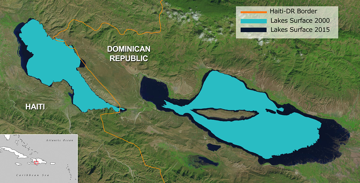
The Hispaniola Lakes Project
The island of Hispaniola holds the two largest landlocked bodies of water in the Caribbean, Lakes Enriquillo and Azuei (also known as Lake Saumatre), with surface areas (as of March 2013) of approximately 350 km2 and 140 km2, respectively. These lakes are located in each of the two countries that share Hispaniola: the Dominican Republic (Enriquillo lake) and Haiti (Azuei). Since 2004, the lakes have experienced a rapid expansion in surface area causing major flooding to the surrounding agricultural and cattle-raising lands, infrastructure, and communities.
The main goal of this project is to understand why the lakes are expanding at such a rapid rate, so that we can accurately forecast how they will behave in the future. This information is crucial for sustaining local livelihoods and for informing decision makers on the best policy options to address this pressing problem. Also, we would like to share the lessons learned with the international community so the project can contribute to and benefit from knowledge gathered from similar situations worldwide.
Puerto Rico
Convection, Aerosol, and Synoptic-Effects in the Tropics (CAST)
In order to study the large and local scale contributions to convective storm production,
we launched the Convection, Aerosol, and Synoptic-Effects in the Tropics (CAST) experiment.
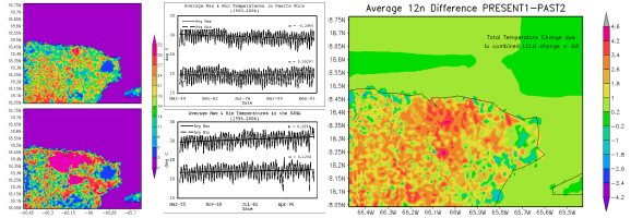
Based in Puerto Rico, CAST included measuremen ts from remote and ground-based sensors, including a three-channel LIDAR system, a ceilometer, multiple sunphotometers in the Aerosol Robotic Network (AERONET), soil moisture sensors, radiosondes, a disdrometer, surface weather stations, Next Generation Weather Radar System (NEXRAD), high resolution TropiNet radar, and satellite imagery. CAST provided an opportunity to understand how the North Atlantic Oscillation (NAO), El Niño Southern Oscillation (ENSO), Saharan dust (SD), sea surface temperature (SST), vertical wind shear (VWS), the North Atlantic High Pressure (NAHP) acted along with local scale dynamics such as orography and local convergence to cause the most extreme Caribbean drought in recent history. CAST data (Figure 2) shows a highly convective but dry local environment.
Impacts of Land Cover/Land Use Changes in Coastal Tropical Regions under a Changing Environment

Tropical coastal areas represent an interesting case in which global, regional and local effects converge thru general atmospheric circulations, large urban centers, and pristine rain forests. Because of this unique combination of factors, tropical coastal regions, which represent a major part of the global biodiversity hotspots (Myers et al. 2000), require focused attention and provide the perfect setting to conduct total climate impact studies due to LCLU Change + Global Warming. The Northeast region of the Caribbean island of Puerto Rico offers a unique opportunity as a test case for environmental change and climate impact studies because of the interaction in a limited geographical area between the San Juan Metropolitan Area, the Luquillo Experimental Forest (El Yunque), the Central Mountain range, and kilometers of developed and pristine coastline.